Difference between revisions of "RMW: Contoh Disain Sambungan Wireless"
Onnowpurbo (talk | contribs) |
Onnowpurbo (talk | contribs) |
||
| Line 2: | Line 2: | ||
Digipeater YC1LZ-2 | Digipeater YC1LZ-2 | ||
| − | Longitude 6 43.94" South (atau | + | Longitude 6 43.94" South (atau 6 45' 31") |
| − | Latitude 107 35.36" East (atau 107 | + | Latitude 107 35.36" East (atau 107 36' 01") |
Locator OI33TF27BW | Locator OI33TF27BW | ||
HAAT 1561 meter | HAAT 1561 meter | ||
| Line 9: | Line 9: | ||
Power 16 Watt | Power 16 Watt | ||
Lokasi BNPB Tangkuban Perahu | Lokasi BNPB Tangkuban Perahu | ||
| + | |||
| + | Jika di perlukan lakukan konversi koordinat GPS menjadi dari | ||
| + | |||
| + | DDD MM.MMM > DD MM SS | ||
| + | |||
| + | menggunakan fasilitas di | ||
| + | |||
| + | http://www.levinecentral.com/ham/grid_square.php | ||
| + | |||
| + | |||
==Masukan Data Unit== | ==Masukan Data Unit== | ||
| Line 20: | Line 30: | ||
Name YC1LZ-2 | Name YC1LZ-2 | ||
Elevation(m) 1561 | Elevation(m) 1561 | ||
| − | LAT LON or QRZ | + | LAT LON or QRZ |
| + | Longitude 6 43.94" South (atau 6 45' 31") | ||
| + | Latitude 107 35.36" East (atau 107 36' 01") | ||
Lock di klik | Lock di klik | ||
| Line 59: | Line 71: | ||
[[Image:Rmw4.jpeg|center|200px|thumb]] | [[Image:Rmw4.jpeg|center|200px|thumb]] | ||
| + | |||
| + | Setelah Unit YC1LZ-2 di masukan maka kita akan melihat pada peta | ||
| + | |||
| + | [[Image:Rmw5.jpeg|center|200px|thumb]] | ||
| Line 105: | Line 121: | ||
Page principale - Home page | Page principale - Home page | ||
| + | |||
| + | |||
| + | |||
| + | ==Referensi== | ||
| + | |||
| + | * http://www.csgnetwork.com/gpscoordconv.html | ||
| + | * http://www.levinecentral.com/ham/grid_square.php - perhitungan Locator | ||
Revision as of 14:15, 11 March 2011
Dalam contoh ini akan kita coba lihat coverage pancaran dari
Digipeater YC1LZ-2
Longitude   6 43.94" South (atau   6 45' 31")
Latitude  107 35.36" East  (atau 107 36' 01")
Locator   OI33TF27BW
HAAT      1561 meter
Antenna   4 dBi Omni
Power     16 Watt
Lokasi    BNPB Tangkuban Perahu
Jika di perlukan lakukan konversi koordinat GPS menjadi dari
DDD MM.MMM > DD MM SS
menggunakan fasilitas di
http://www.levinecentral.com/ham/grid_square.php
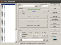
Masukan Data Unit
Klik
File > Unit Properties
Masukan data
Name            YC1LZ-2
Elevation(m)    1561
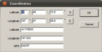
LAT LON or QRZ
Longitude   6 43.94" South (atau   6 45' 31")
Latitude  107 35.36" East  (atau 107 36' 01")
Lock            di klik
Hasilnya akan tampak pada gambar
Masukan Data Peta
Klik
Files > Map Properties > Enter LAT LON or QRA
Masukan data
OI33TF27BW
Seperti tampak pada gambar
Pilih
Elevation Data Source > SRTM > Browse > Z:/home/onno/Geodata/srtm3
Atur lebar peta secukupnya. Default 50 km. Kita dapat memperlebar misalnya 300 km.
Height > 300
Jika semua sudah selesai klik
Extract
Semakin lebar peta / wilayah yang ingin di analisa, akan membutuhkan waktu lebih lama untuk download file SRTM yang dibutuhkan. Untuk frekuensi VHF kita bisa menganalisa untuk jarak 300 km-an jika kita pasang repeater di sebuah Gunung.
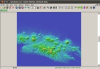
Hasilnya adalah sebagai berikut
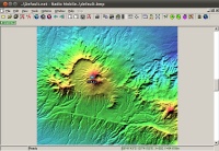
Setelah Unit YC1LZ-2 di masukan maka kita akan melihat pada peta
2. Extract elevation data and create a map picture
Launch Radio Mobile program. In "Files" menu, select "Map Properties", and enter the following values:
Click on the "Apply" button. Once data extraction is finished, the program will generate the following picture:
Use "Picture properties" to force "Gray scaled slope" mode.
3. Position my QTH
Open "Unit properties" in the "Edit" menu and click on "Enter Latitude and Longitude". Fill as per the following:
Back to "Unit properties" insure that the unit is enabled and that a 38m elevation is shown before to apply, repeat for mobile:
4. Enter Network data
Open "Networks properties" in the "Files" menu and fill as per the following:
Net parameters tab:
Net topology tab:
System tab for base:
System tab for mobile:
Net membership tab for base:
Net membership tab for mobile:
On apply, the program is ready for Radio Coverage!
4. VHF Radio coverage!
In "View" menu, select "Radio coverage polar" and complete form as per the following:
Click "Apply" button to obtain the resulting picture.
Page principale - Home page
Referensi
- http://www.csgnetwork.com/gpscoordconv.html
- http://www.levinecentral.com/ham/grid_square.php - perhitungan Locator


